Wolston is a relatively large village situated midway between Rugby and Coventry. In 1863 it was described as a large pleasant village and parish, including the hamlets of Marston, Brandon and Bretford. Wolston appears in the Domesday Book as "Vivricetone" and "Vivestone.
In the last census, in 2011, the population was 2,564 people living in 1175 resident households. The population of Wolston in 2001 was 2,422 living in 940 resident households. By contrast, in 1861, the population was 814. A latest (2018) estimate for population is 2,734.
Three main streets form the backbone of the village - School Street, Warwick Road (previously known as Warwick Street) and Main Street (previously known by various names including The Sreet, Avon Street and Station Road).
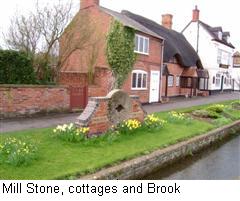
The most eye-catching of these is Main Street with its jumble of grand houses and charming cottages, two of the village's three public houses, the Baptist Chapel, the War Memorial, the old Post Office and the Village Hall.
Mill Stone cottages and brookA small stream, which enters the village at the far end of Brook Street, is channeled past the front of a number of properties in Brook Street, then under Warwick Road, before re-emerging at the top of Main Street where it is again channeled in front of the properties down to The Beeches. From here it meanders through the Church Field to join the River Avon.
Wolston St Margaret's Primary School, set in secluded surroundings that were originally the walled kitchen garden belonging to the Manor House, replaces the earlier Victorian school building on School Street, which has been converted for business use. The picturesque St. Margaret's Church, believed to be of Saxon origin, with Norman and later additions, stands near the River Avon. In 2008, essential repairs to the stonework of the buildings north and west sides were completed.
 As you enter the village from Brandon, over the 18th century river bridge, you pass Avon Terrace. Originally to the rear of the houses that form Avon Terrace was Cash's Artificial Silk Mills, later to become Bluemels Brothers bicycle factory. When the factory closed it was replaced by a Business Park which had some thriving units on it. However the land had to be sold so the units were demolished and replaced with a housing estate - Bluemel Park - which contains St. Margaret's Avenue and Bluemel's Drive.
Continuing south towards the village centre you reach Meadow Road and Hawthorn Close. Originally meadows known as Berry's Field it is now a housing estate. Over the years Meadow Road has been extended and now links up with Priory Road. Radiating off Meadow Road are Willowbrook Road, Elmdene Close, Larchfields, and Abbots Walk.
Leading off School Street is Dyers Lane and Lammas Court. Dyers Lane contains the Cemetery, with its former mortuary chapel, a closed Baptist Burial ground, and the Recreation Ground providing a Pavilion, Scout Hut, and children's Play Area.
Further along Warwick Road is Brook Street, with some properties reputed to date back to the early 18th Century; Wolston Garage and the access road to the "new" Vicarage are also in Brook Street.
Opposite Brook Street is found Derry Close, and continuing up Warwick Road on the right is the Half Moon, the village's third public house. On the left is the Old Vicarage, the gardens of which became John Simpson Close and Chestnut Grove. Opposite John Simpson Close is the Library and the entrance to Manor Estate and Paddocks Close.
Further up Warwick Road on the left is the entrance to Stretton Lane, which leads to the excellent Allotments site; further up the road passes a Site of Special Scientific Interest reflecting the glacial (Wolstonian) history of this part of Warwickshire as depicted on the information board near the village green.
A new Leisure and Community Centre was built on part of the site of the old High School in 2003. Wolston High School closed in 1991 as part of a restructuring of Secondary Education provision in the Borough; half the site was sold for housing resulting in Millennium Way, William Cree Close, Mill Close, Salisbury Close and Manor View being built, and the other half was used for the Leisure and Community Centre and playing fields.
Although the village has seen considerable growth in the last 50 years it strives hard - and quite successfully - to retain its character, and there continues to be a very active community spirit !